Better Buses for Alnwick, Warkworth, and Amble: Petition Progress towards 500 Signatures

The petition for better buses to connect the North Northumberland towns of Alnwick, Warkworth and Amble to Alnmouth railway station currently stands at a strong 455 signatures since its launch in February.

Only an additional 45 signatures are needed for this petition to reach 500 signatures, can we reach this in the next few days?
If you’d like to see a better bus service linking these towns to the railway station, please pop your signature on the petition here: https://chng.it/B4RwwtHnJc
CRAG Postcard to Kim McGuinness
In an article today from The Chronicle, the Chathill Rail Action Group (CRAG) have presented a postcard to North East Mayor Kim McGuinness to call for more rail services to Chathill Station, between Alnmouth, and Berwick-Upon-Tweed stations on the East Coast Main Line (ECML) in Northumberland.
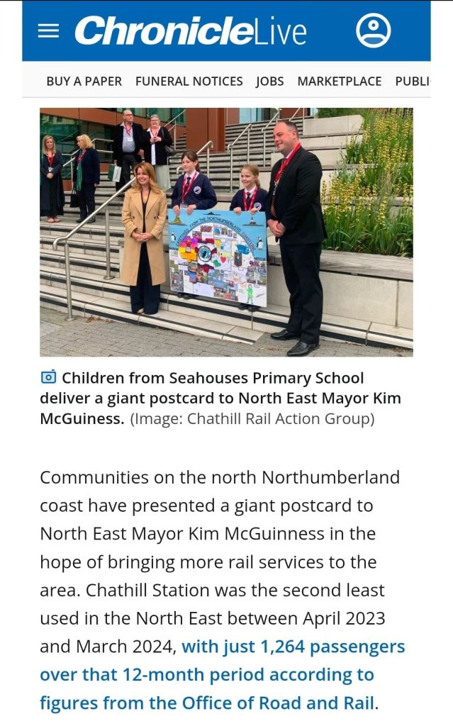
This campaign supports this aim of an enhanced service to Chathill, alongside a new £15m station at Belford, and wider upgrade to the ECML route to see services to stations both large and small improved.
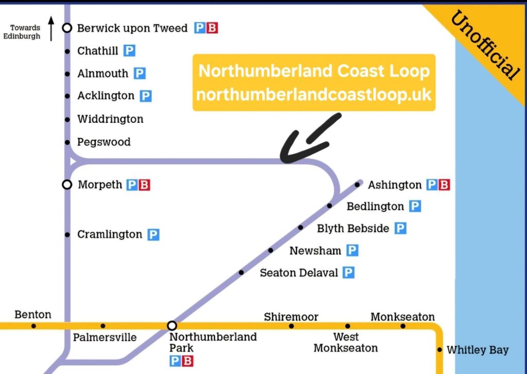
We are also calling for investment to ensure that sufficient capacity is also available for the new Northumberland Coast Loop, which would see a new Newcastle – Bedlington – Edinburgh passenger route developed, giving better to, from, and within Northumberland connections, linking the northern end of the highly successful Northumberland Line back onto the ECML to give towns such as Bedlington, Blyth and Seaton Delaval, as well as the larger conurbation of North Tyneside better rail connectivity.
Schemes such as better rail services and even completely new stations such as proposed one at Belford are far more cost effective than schemes like dualling the A1, a £15m new station is very cost-effective compared to the expected £500m+ cost of dualling just 13 miles of the A1 between Morpeth and Ellingham, and the Northumberland Coast Loop, while not fully costed, uses an existing rail route, in daily use on the ECML and Northumberland Line, with the short link from Bedlington to Pegswood the only section not in regular passenger use, used by freight and the empty passenger trains heading to Ashington each morning.
The petition for the Northumberland Coast Loop route from Newcastle, via Bedlington, to Edinburgh presently stands at 519 signatures as of tonight (9.6.25), and could be a good way to deliver both a better local service to stations such as Chathill, whilst also giving a wider range of connections to, from, and within Northumberland too.

I would like to wish CRAG well with their campaign, and hopefully the N.C.L. will come alongside or swiftly behind!
Phenomenal Petition Performance; Blasting Past 500 Signatures
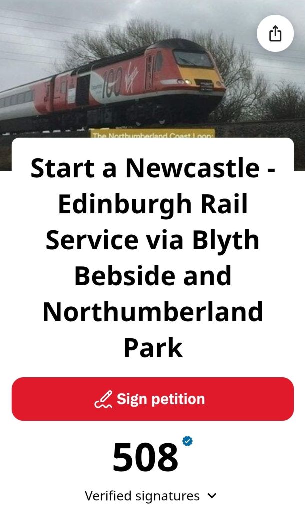
As of the evening of Monday 9th June 2025, the Newcastle – Northumberland Park – Blyth Bebside – Edinburgh Rail Service Petition has gained a phenomenal 508 signatures since it was launched back on the 13th February 2025, a mere 117 days ago, an average of around four/five signatures per day.
This is a great milestone, but the story is far from over; please keep sharing and supporting this campaign to see this rail route become a reality, the track is already there, lets just see the trains run upon it!
Thank you to all who’ve signed it already, and if you haven’t, please do so via the link above!
Yours and kind regards to you all, RH.
Route Of The Rambler! News on the Newcastle – Bedlington – Edinburgh Rail Service Petition 6.6.25
The petition for a Newcastle to Edinburgh rail service via Bedlington & Pegswood is close to reaching 500 signatures, with 474 having signed it to date.
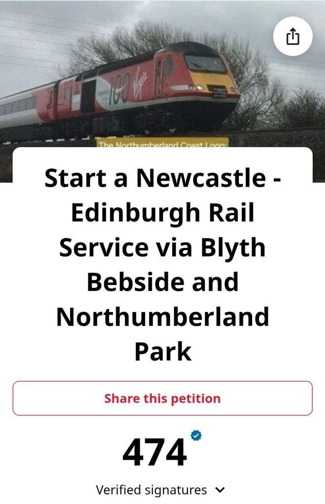
This petition will continue until such a time as a service is trialled over the proposed route, as outlined below in the two maps.
If you would like to sign the petition for this route, please do so here: https://chng.it/zThXj8HBpY
Thanks again to all who have signed it so far, and please share with friends and family to encourage them to sign too!
Green Signals Podcast on the Northumberland Line
This week, Nigel and Richard have made a visit to the Northumberland Line, running from Ashington to Newcastle-Upon-Tyne.
Please view their Part 1 video here: https://youtu.be/Fo1o7dIhW3c?si=PTTSGcd8f6ttL4uh
A follow up video is due soon, which I’ll post here as a Part 2 once it is uploaded.
Good to see the interviews within and it’ll be interesting to see the full episode!
A New Route Map!

A very kindly shared route map from Paul (‘@lf_p’ on Twitter/X), this is a visualisation of a ‘Route Map’ across the North East, ranging from Berwick upon Tweed in the north, down to Horden, and Durham in the south, with Haltwhistle in the west.
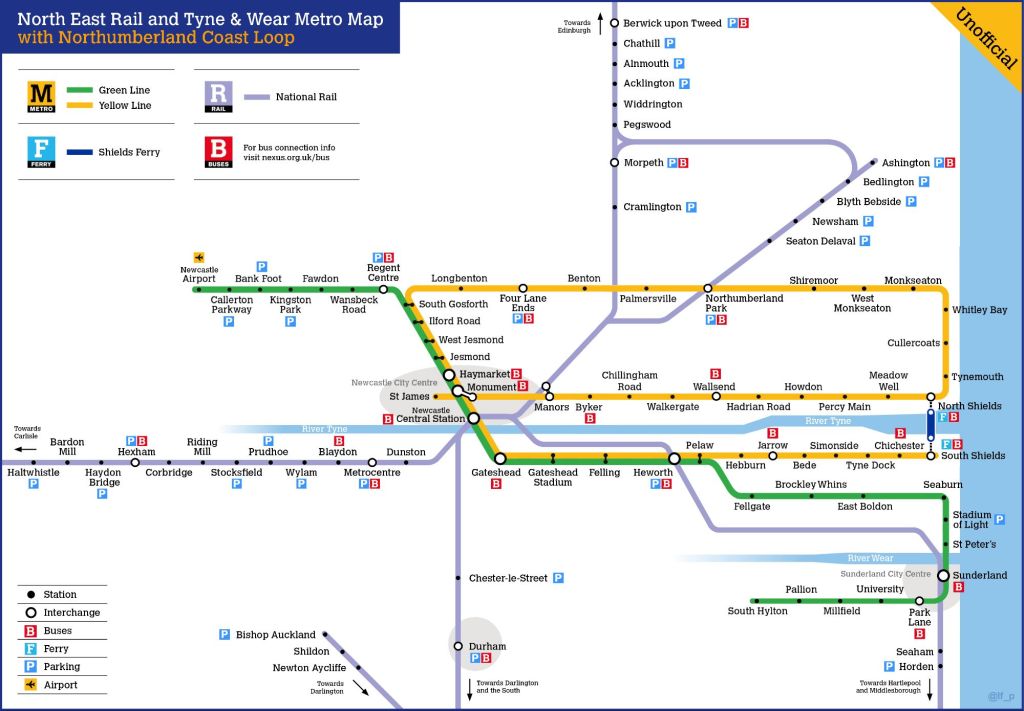
As can be seen from the map above, the proposed Northumberland Coast Loop would leave Central Station and follow the route of the Northumberland Line as far as Bedlington, and in this diagram, would curve back towards the East Coast Main Line (ECML), using the existing line through the village of Hepscott, used predominantly by the GBRf ‘Alcan’ flow from North Blyth to Fort William.
At the triangular junction near Morpeth, the N.C.L. would take the upper curve (the Morpeth North Curve) towards Pegswood, the route then running north towards Berwick Upon Tweed and ultimately Edinburgh, again this route is used regularly for the North Blyth to Fort William railfreight, but sadly little else by way of rail traffic on a regular basis, for the time being?
The map above from the SRPS is a more ‘true to geography’ map compared to the above route diagram (in a T&W Metro style), but the Metro style map perhaps shows the layout of lines more clearly, and illustrates why Morpeth and Ashington can’t be directly served by the proposed Northumberland Coast Loop route.
Hopefully these maps make the proposed Northumberland Coast Loop proposal easier to understand.
The petition for this route is continuing to perform strongly, and if you’d like to see it implemented, please sign it here: https://chng.it/J8DxHqpWdf
Thanks again to Paul for providing the above image, it is very much appreciated!
N.C.L. in the NEPTUG Newsletter & Alnwick to Amble ‘Bus Meets Train’
The Summer 2025 issue of the NEPTUG Newsletter features a mention of the campaign for the Northumberland Coast Loop as one of the proposed expansions of the highly successful Northumberland Line.

Thanks to NEPTUG for asking for a contribution towards the Newsletter and hopefully a route that can be introduced rapidly, as it is already in place, it simply needs the service to run!
The Berwick – Blyth – Newcastle Coastal Rail Route
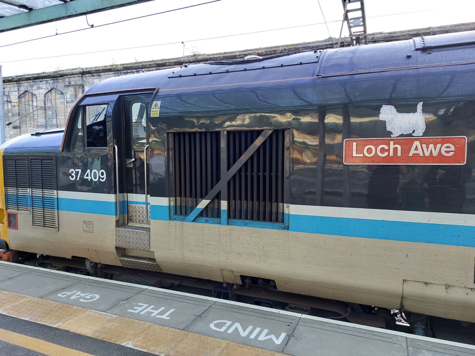
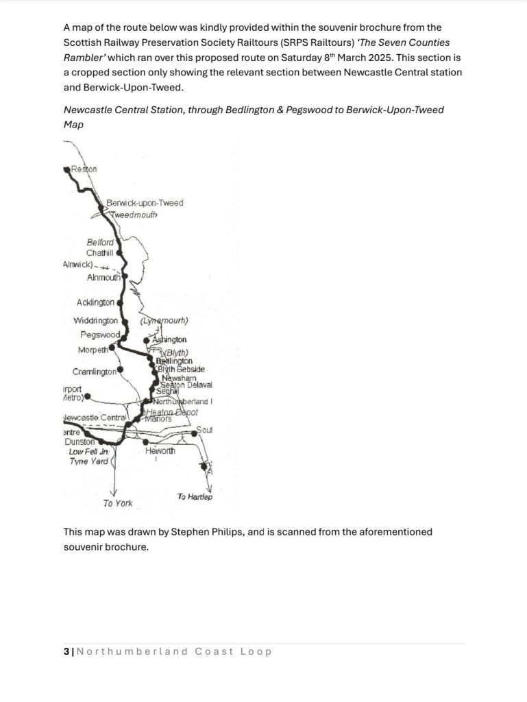
As we often reiterate here, the proposed service starting at Newcastle Upon Tyne and running through Nortumberland Park, Blyth Bebside, Bedlington, Pegswood, Alnmouth (for Alnwick), Berwick Upon Tweed, and other Scottish stations such as Reston, Dunvar etc on the route to Edinburgh route is feasible today, as all the track required already is in place; as demonstrated by a recent railtour operated by the Scottish Railway Preservation Society, named ‘The Seven Counties Rambler’.
The map above was taken from ‘The Seven Counties Rambler‘ railtour brochure of March 2025, which traversed the route in the late evening of 8th March. A video of this railtour passing through Northumberland Park on that day can be seen here: https://youtu.be/Yf2SSoniR4E?feature=shared
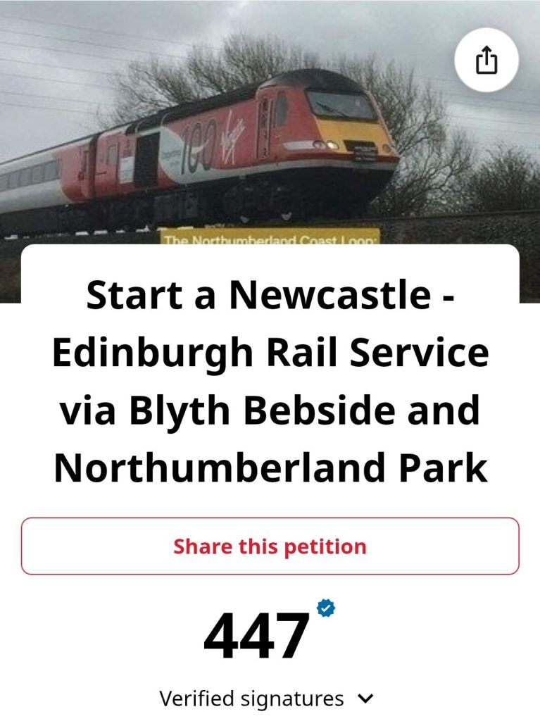
The Northumberland Coast Loop proposal is just for a rail service, with all of the stations on the route map below either already built and serving passengers, or in the final stages of contruction and due to open later this year (2025),

While line capacity on the Northumberland Line and East Coast Main Line (ECML) might pose some challenges, it should be far from impossible to deliver at least a handful of Newcastle – Edinburgh via Bedlington services to start with (perhaps five trains per day in each direction), with potential for such a route to perhaps run hourly in time.
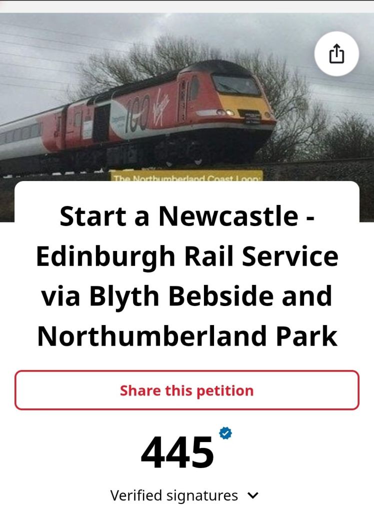
As can be seen above, as of 2nd June, the petition for the route stands strong at 445 signatures, with more being added daily! If you’d like to sign too, please do so here: https://chng.it/J8DxHqpWdf
Alnwick – Alnmouth Station – Warkworth and Amble ‘Bus Meets Train’ Service
Very much in the same vein of providing better public transport connections is another petition for improved bus connections between Alnwick, Amble, and Warkworth to Alnmouth Railway Station.

This proposal is to better reconnect the North Northumberland towns of Alnwick and Amble, which have long been off the rail network, into the key railway hub for the area at Alnmouth Station.
The petition again for this is performing well, and if you’d like to add your signature, please do so here: https://chng.it/B4RwwtHnJc
Improve Existing Buses?
This could be partially delivered through some improvements to existing bus routes such as the X18 and X20 services, where as can be seen below, the X18 omits the station on its route, whilst the X20 travels up South View and Curly Lane to provide a proper interchange between bus and rail services.
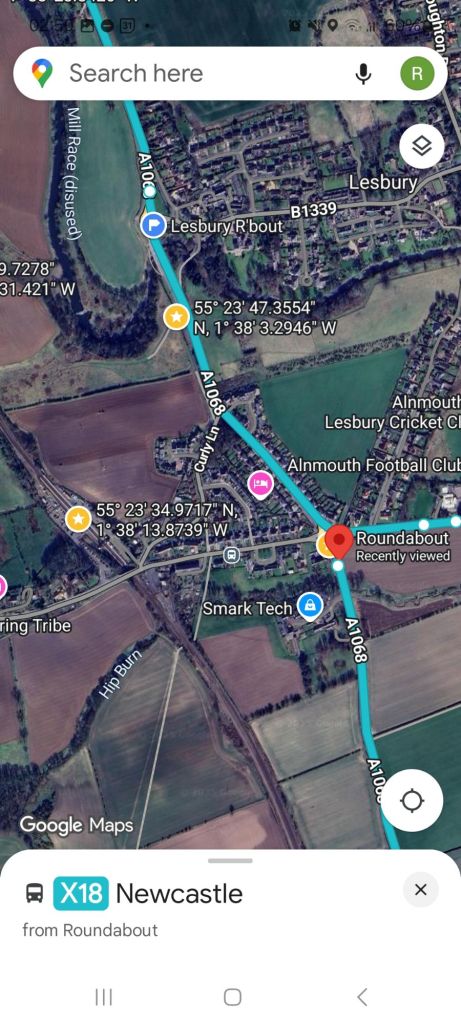
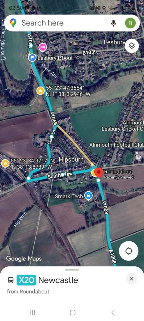
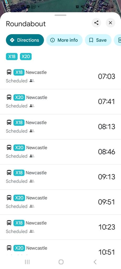
Taken together, these two services give around two buses per hour near to the station, but the variation in timings means that buses are not running a consistent timetable, for example the X18 towards Newcastle at 07:03 is then followed by the 07:41 X20 (38mins later), then the next X18 at 08:13 (32 mins later).
A simplification of the timetable could give a much more understandable ‘clockface’ schedule, with arrivals/departures at xx:15 and xx:45 appearing to be reasonable amendments given buses running near to these times already.
That being said, Arriva bus services have been remarked upon by a number of people on social media as having a reputation for being late and/or unreliable (buses failing to turn up at all), which if making rail connections could mean failing to make your inward or outward trip, and with consequences in costs for rebooking rail travel or needing to hire taxis etc.
Hopefully Arriva can run their buses to a more sensible and understandable clockface timetable, and run their buses on-time and reliably as a good starting point?
New Bus Service?
There could be an advantage however in running a dedicated bus route alongside longer distance buses, which would form a link between Alnwick Bus Station (a possible site for a ‘virtual railway station’, similar to that done in Keswick, Cumbria), Alnmouth Railway Station, Warkworth Castle, and Amble High Street.
This new service could be operated by other bus companies such as Glen Valley Tours, the operator which runs local services such as the 472 between Shilbottle and Barresdale (itself a service that might usefully be extended from Shilbottle to Alnmouth Railway Station via High Buston).
To and from Alnwick, rather than around it?

In 2024, a free local bus ran around within Alnwick itself, providing connections between attractions inside of Alnwick, but within a compact and walkable town, it could be arguably better to improve the public transport offer to and from Alnwick as whole; it need not be a free service, but it could, like the free bus service last year be supported/branded by larger attractions such as Alnwick Castle, The Alnwick Garden, and bus tickets maybe could even be integrated into pre-booked attraction tickets?
Please leave a comment below with your thoughts and share where you usually do!
Northumberland Coast Loop Petition: 30th May 2025
As of this morning, the Northumberland Coast Loop Petition, stands at a brilliant 425 signatures this morning.

This petition aims to see the introduction of a new rail route between Newcastle and Berwick/Edinburgh via Bedlington, directly linking the newly opened Northumberland Line stations to North Northumberland and Scotland, rather than the current situation of transferring between trains at Newcastle Central Station.
Using the Existing Route Regularly
On 8th March 2025, I was fortunate to be a passenger aboard the SRPS Railtours ‘The Seven Counties Rambler‘, which took the proposed route between Newcastle and Edinburgh via Bedlington as part of a ‘rare-track’ railtour around Scotland and Northern England, showing how readily this route could be brought into regular passenger use.
Compared to routes such as the Leamside Line, which will require track to be relaid before any trains can run, the link line between Bedlington Junction and Morpeth North Junction is used multiple times per week by the GBRf operated ‘Alcan’ train between the dock at North Blyth and the aluminium smelter in Fort William.
The route has a history of being used for diversions around Morpeth when required, but the huge popularity of the Northumberland Line shows that a new rail service headed north could be a great addition to these brand new stations, and could help deliver further economic benefit to Northumberland as a whole.
If you haven’t already signed the petition, please do so here: https://chng.it/J8DxHqpWdf
Alnwick, Alnmouth and Amble ‘Bus Meets Train’ Petition at 100 Days

It is now 100 days since the petition calling for improved bus services between Alnwick, Alnmouth Railway Station, Warkworth, and Amble was launched, and so far, it has gained the support of 442 people.
A better bus service would make access to and from Alnwick to Alnmouth station easier to do by road, improving the present hourly service to half hourly would be the target, and for the buses to follow a ‘clockface’ schedule of xx and yy mins past the hour to depart towards the station or arrive back from it.
The service would be intended to use conventional buses, and at usual bus fares, not as some have commented online by running luxury coaches etc.
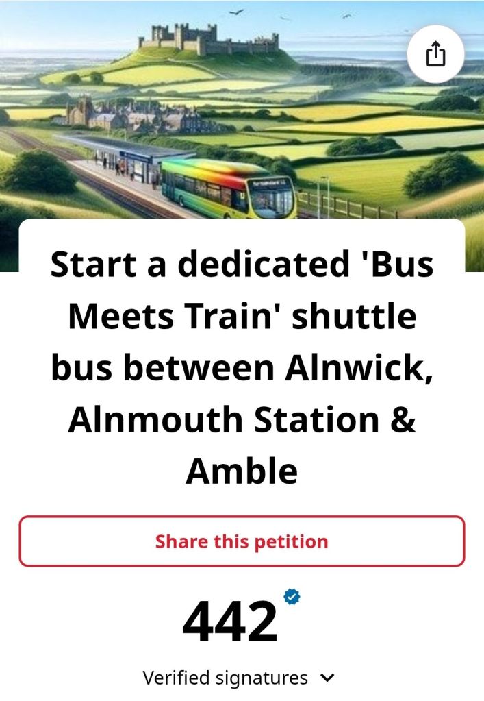
If you would like to add your signature, please do so here: https://chng.it/B4RwwtHnJc
